A GEOPHYSICAL INVESTIGATION USING SEISMIC REFRACTION METHOD TO DETERMINE THE CAUSES OF ROAD FAILURE
ABSTRACT
This project work was carried out at Ireukpen-Ozalla Road Axis Ekpoma, Esan-West Local Government Area Edo State. Using seismic refraction prospecting method to examine the cause(s) of the persistent failure of the road. An ABEM TERRALOC MARK-6 Seismometer was used as the recording instrument and twelve geophones as wave detectors in series with one another. The geophones were spread at predetermined distances and the impact of a sledge hammer on a flat plate served as the source of generating seismic waves. The “SERCOM1” software was employed in the interpretation of the field result for the forward and reversed shooting respectively… (Scroll down for the link to get the Complete Project Material)
INTRODUCTION
The incessant incidence of pavement failure of road structure is becoming alarming and has become a common phenomenon in many parts of Nigeria. These failures have been attributed to a number of factors such as inadequate information about the soil and the incompetence of these subsurface geologic materials. Failures are not limited to any particular geologic setting… (Scroll down for the link to get the Complete Project Material)
Road Development In Nigeria
The Government of Nigeria is committed to improve road network within the country and this venture is laudable since to a great extent, it will enhance her economic development. Recent years have seen a major development in the infrastructure of this area, including several new roads linking the towns and villages.
The road network is currently estimated at about 194,000 kilometers, with the Federal Government being responsible for about 17 percent, State Governments 16 percent and local Governments 67 percent (FMW&H). This has led to a situation, whereby for a variety of reasons, roads were constructed in areas with a history of surface and subsurface geological degradation. In spite of various rehabilitation efforts, several segments of our highways fail perpetually soon after commissioning.
Such rehabilitation has become an annual ritual and a big financial burden on various tiers of Government (Adiat et al. 2009). This has resulted in the need for reparations and the use of remedial measures to ensure the usability of the transportation network (Hadjigeorgiou, 2006)… (Scroll down for the link to get the Complete Project Material)
Definition Of Road Pavement Failures
Road pavement failure can be defined as a discontinuity in a road network resulting from cracks, potholes, bulges, and depression. A road network is supposed to be a continuous stretch of asphalt layer for a smooth ride. Visible cracks, potholes, and depressions generally regarded as road failure may punctuate such smooth ride (Rahaman 1976, Aigbedion 2007).
Flexible highway (i.e. good and well-developed interconnectivity of roads) aids easy and smooth’s vehicular movement, and have been very useful for transportation of people, goods and services from one point to another, especially in developing countries where other means of transportation such as rail, underground tube, air, and water transportation systems have remained largely undeveloped… (Scroll down for the link to get the Complete Project Material)
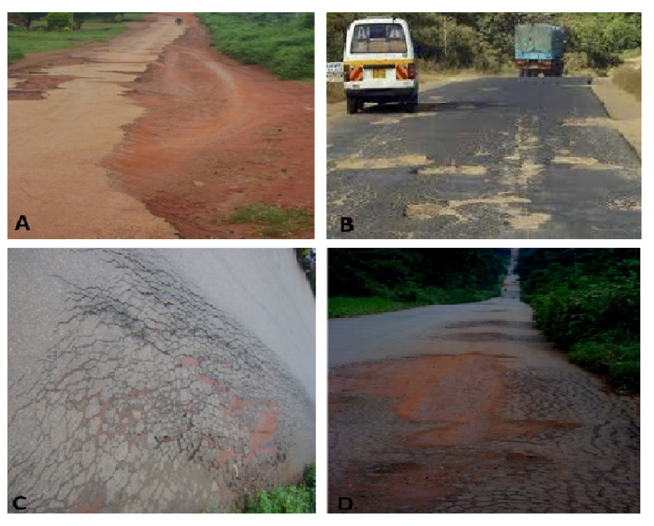
PLATE 1: (A) Failed section of Opoji old road along Opoji – Irrua road (B) Pavement surface removal after rehabilitation along Uhiele – Opoji road (C) Zoomed section showing very thin coating of the pavement surface (D) Longitudinal view of Uhiele – Opoji road with very thin surface coating.
Mineralogy of Sub-base
Geological factors are rarely considered as precipitators of road failure even though the highway pavement is founded on the geology. (Momoh et al., 2008, Ozegin et al., 2011). Some sections of major roads failed because their soil properties were not thoroughly investigated at the initial state.
In fact, little or no consideration was given to the effect of clay mineralogy and the associated engineering soil behaviour, as highway foundation materials. The bearing capacity of rocks in relation to traffic is one the essential parameters to be reckoned with, in road construction projects. Some major Nigerian highways are known to fail shortly after construction and well before their design ages.
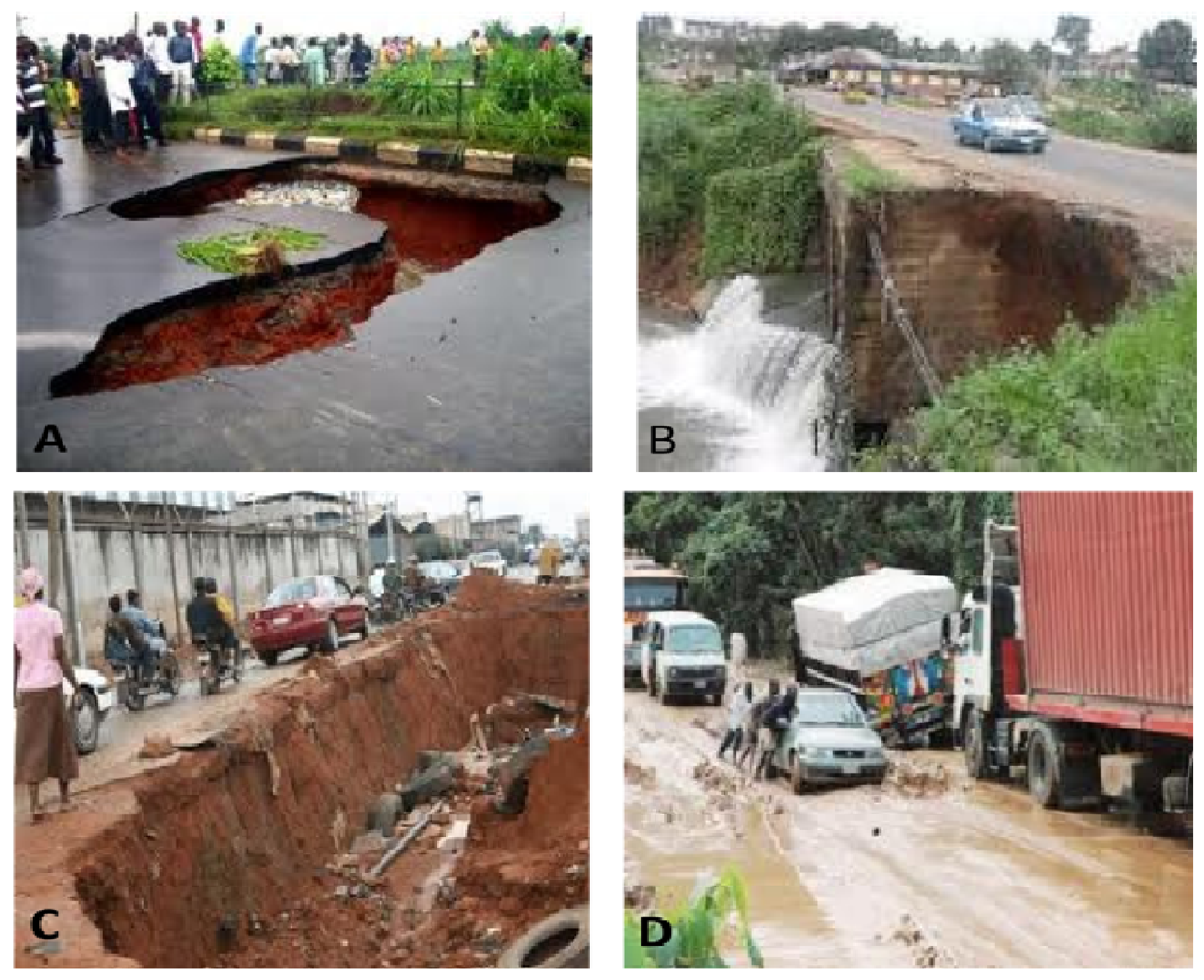
PLATE 2: Major Highways failing before their design age within the state. (A) A Federal highway route in the country (B) and (C) Roads collapsing due to lack of proper drainage system within the state in Benin metropolis (D) Benin – Ore road (2010) (Wednesday, 13 July 2011, Nigerian Compass)… (Scroll down for the link to get the Complete Project Material)
Statement Of The Problem
The roads to be investigated serve as a link between the University town of Ekpoma and the major high way leading to the Eastern part of Nigeria. The occupation of the people living in this part of the town is predominantly farming. The failures of these roads have generated a lot of problems of which a few are listed below;
Farm produce from these communities hardly get to the outside market as a result of bad road network… (Scroll down for the link to get the Complete Project Material)
METHODOLOGY
Geophysical Investigation Methods
Geophysical methods provide information about the physical properties of the earth’s subsurface. There are two general types of method: the active, which measures the subsurface response to electromagnetic, electrical and seismic energy; and a passive, one which measures the earth’s ambient magnetic, electrical, and gravitational fields. Information provided by these methods can be applied to sites with undesired or buried objects, to determine other geologic and hydrogeologic conditions, of the subsurface.
Geophysical methods can also be subdivided into either surface or borehole methods. Geophysical methods have been used for nearly 70 years, although predominantly in the exploration for natural resources. Oil, gas and mineral exploration demanded better technologies to locate and define highly needed natural resources before and during World War II. Since the 1950s, the use of geophysics in the natural resource exploration industry has increased to the point that it is used as the first level effort on every project… (Scroll down for the link to get the Complete Project Material)
The Principle Of Seismic Refraction Method
Seismic refraction methods have been extensively used in petroleum, mineral, and engineering investigation and to some extent for hydrogeologic applications. During the past years, advances in equipment, sound sources, and computer interpretation techniques make the seismic refraction method highly effective and economical for obtaining data for subsurface modeling studies (Haeni 1986).
Imai and Tonouchi (1982) studies P- and S-wave velocities in an embankment and also in alluvial, diluvia, and tertiary layers, showing that S-wave velocities in such deposits correspond to the N value (Craig 1992) index value of formation hardness used in soil mechanics and foundation engineering.
Surface waves are guided and dispersive. Rayleigh waves are surface waves that travel along a free surface, such as the earth–air interface (Jianghai et al. 1999)… (Scroll down for the link to get the Complete Project Material)
The resistivity method is used in the study of horizontal and vertical discontinuities of the ground. It can also be used in the detection of three-dimensional bodies of anomalous electrical conductivity. It is routinely used in engineering and hydrogeological investigations of shallow subsurface geology.
The method uses artificially- generated low-frequency electric currents, introduced into the ground and the resulting potential differences are measured at the surface. Deviations from the expected pattern of potential differences from homogeneous ground provide information on the form and electrical properties of subsurface inhomogeneities… (Scroll down for the link to get the Complete Project Material)
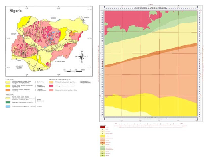
Fig 1. Geological Map of Nigeria
SAS 1000 performed automatic recording of both voltage and current, stacked the results, computed the resistance in real time and digitally displays it [11], [34]. The Terrameter was configured in a mode that it displays apparent resistivity and induced polarization data automatically at the same time… (Scroll down for the link to get the Complete Project Material)
RESULTS AND DISCUSSION
The data collected were automatically fed into the instrument to generate a two dimensional (2-D) resistivity model for the subsurface which can be referred to as Electrical Image. These values obtained were used for the qualitative interpretation of the profiles.
Two dimensional (2D) electrical imaging surveys are widely used to map areas of moderately complex geology where conventional resistivity surveys and profiling may be inadequate. The results from such surveys are usually plotted in the form of a pseudosection which gives an approximate picture f the subsurface geology.
Dense sampling of subsurface resistivity variation at shallow depth (electrode spacing of 10m) aims to investigate the lateral variation in electrical properties. Expanding the Wenner array spacing (20m; 30m; 40m) characterized its sensitivity for vertical variation in the subsurface resistivity below the center of the array… (Scroll down for the link to get the Complete Project Material)
| Profile 1 | Layer | Least Value | Maximum Value | Inferred Lithology |
| Resistivity | 1 | 798.76 | 2335.3 | Shales/Clays |
| (Ohm-m) | 2 | 273.94 | 3293.2 | Shales/Clays |
| 3 | 310.04 | 2523 | Shales/Clays | |
| 4 | 412.79 | 3566.7 | Shales/Clays | |
| Profile 2 | Layer | Least Value | Maximum Value | Inferred Lithology |
| Resistivity | 1 | 1561.2 | 2214.4 | Shales |
| (Ohm–m) | 2 | 1614.7 | 3034.2 | Shales |
| 3 | 2657.7 | 3534.4 | Shales | |
| 4 | 3151.4 | 4062.4 | Sandstones | |
| Profile 3 | Layer | Least Value | Maximum Value | Inferred Lithology |
| Resistivity | 1 | 714.36 | 1687.7 | Shales/Clay |
| (Ohm-m) | 2 | 1211.2 | 2511.7 | Shales |
| 3 | 2018.7 | 3856.4 | Shales | |
| 4 | 2281.7 | 3193.9 | Shales | |
| Profile 4 | Layer | Least Value | Maximum Value | Inferred Lithology |
| Resistivity | 1 | 700.06 | 999.72 | Clays |
| (Ohm-m) | 2 | 789.78 | 1995.54 | Clays |
| 3 | 1288.55 | 3984.59 | Shales | |
| 4 | 1231.54 | 3994.65 | Shales |
Along the second profile (Table 1), the different electrode spacing (10m, 20m, 30m, and 40m) showed different resistivity ranges. The apparent resistivity values at a shallow depth of 5m range between 1561.2 ohm-m to 2214.4 ohm-m… (Scroll down for the link to get the Complete Project Material)
CONCLUSION AND RECOMMENDATION
Conclusion
The stability of natural and engineered structures such as buildings, roads, dams, bridges, etc, is the most vital aspect of geotechnical engineering. Geophysical methods (geoelectrical, ground-penetrating radar, seismic refraction, etc) have become increasingly applied in engineering site characterization because it is rapid and an implied cost-effective method… (Scroll down for the link to get the Complete Project Material)
Recommendations
The survey has facilitated a better understanding of the causes of road failure and the characterization of a segment of the Uhiele – Opoji road. In other to forestall future occurrences of road pavement failures in this study area and other similar sites, it is recommended that;
- Detailed geophysical investigation should be carried out on any proposed site for road construction and/or rehabilitation before embarking on the project in order to ensure long term stability and integrity of the pavement… (Scroll down for the link to get the Complete Project Material)
REFERENCES
Adiat, K.A.N., Adelusi, A.O. and. Ayuk. M. A., (2009). Relevance of geophysics in road failures investigation in a typical basement complex of Southwestern Nigeria. Pacific Journal of Science and Technology. 5(1): 528 – 539.
Adiat, K.A.N., Adelusi, A.O., and Amigun J.O., (2009). Integration of surface electrical prospecting methods for fracture detection in precambrian basement rocks of Iwaraja area Southwestern Nigeria (Seismic Refraction)(Seismic Refraction). Ozean Journal of Applied Sciences 2(3): 1943 – 2429.
Adegoke, Anthony, W.C. and Agada, O.A., (1980). “Geotechnical characteristics of some residual soils and their implications on road design in Nigeria (Seismic Refraction)”. Technical Lecture. Lagos, Nigeria. 1 – 16.
Agwae, G. O. (2011). Geology, geochemistry and industrial potentials (Seismic Refraction) of marble deposits in Igarra Area, Southwestern Nigeria. An Unpublished M.Sc Thesis. Pp 23 – 33.
Aigbedion, I. (2007). Geological and geophysical evidence for the road failures in Edo state, Nigeria. Environmental Geology, Berlin, Pp 101- 103.
Aizebeokhai, A. P. (2010). 2D and 3D geoelectrical resistivity imaging (Seismic Refraction): Theory and field design Scientific Research and Essays 5(23): 3592-3605
Aizebeokhai, A. P., Olayinka, A. I., Singh, V. S. and Uhuegbu, C. C., (2011). Effectiveness of 3D geoelectrical resistivity imaging using parallel 2D profiles (Seismic Refraction). International Journal of the Physical Sciences 6(24): 5623 – 5647.
Ajayi, L.A. (1987). Thought on road failures in Nigeria. The Nigerian Engineer. 22 (1): 10 – 17.
Akintorinwa, O. J. and Adeusi, F. A., (2009). Integration of geophysical and geotechnical investigations (Seismic Refraction) for a proposed lecture room complex at the Federal University of Technology, Akure, SW, Nigeria. Ozean Journal of Applied Sciences 2(3): 1943 – 2429.
Akintorinwa O. J. and Adesoji J. I., (2009). Application of Geophysical and Geotechnical Investigations in Engineering Site Evaluation. International Journal of Physical Sciences 4(8): 443 – 454.
Alile, O. M., Ujuanbi, O. and Evbuomwan, I. A., (2011). Geoelectric investigation of groundwater in Obaretin –Iyanomon locality, Edo state, Nigeria. Journal of Geology and Mining Research 3(1): 13 – 20.
Amidu S. A. and Olayinka A. I., (2006). Environmental assessment of sewage disposal systems using 2D electrical resistivity imaging and geochemical analysis: A case study from Ibadan, Southwestern Nigeria. Environ. Eng. Geosci., 7(3): 261-272.
Asseez, L. O., (1976). Review of the stratigraphy, sedimentation and structure of the Niger Delta. In Geology of Nigeria (Seismic Refraction) (C.A. Kogbe, ed.) Lagos, Elizabethan Publishing Company, Nigeria. pp. 259 – 272.
Auken E, Pellerin L, Christensen N. B, and Sorensen K (2006). A survey of current trends in near-surface electrical and electromagnetic methods (Seismic Refraction). Geophys., 71(5): 249-260.
Bagnold, H. M., (1999). Geophysical technique for buried wastes and waste migration. Environmental Monitoring lab. System. Vegas. Pp 15.
Baldi G, Bellotti R, Ghionna V. N, and Lo Presti D.C.F, (1995). Modulus of sands from CPT and DMT: Proceedings of the 12th International Conference on Soil Mechanics and Foundation Engineering, pp.165–170.
Barker R. D. (1981). The offset system of electrical resistivity sounding and its use with multicore cable (Seismic Refraction). Geophy. Prosp., 29: 128-143.
![]()
![]()
(Get the Complete Project Material)
| MESSAGE US Need quick, reliable writing support? Message us Now and we’ll match you with a professional writer who gets results! or email your files to [email protected] |